Hi,
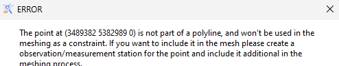
I’m new in OpenGeoSys. I’m trying to reproduce the results of the tutorial for Groundwater flow modeling, but I got stuck in the section “Surface meshing”. After I load all SHP files, I follow exactly what the manual said, go to "Mesh generation → Create 2D mesh from input data .. etc " but when runnig it I get this error and no mesh is created:
Besides, in the console I get this
[2025-05-08 17:09:26.992] [ogs] [info] Start meshing …
[2025-05-08 17:09:26.994] [ogs] [warning] PointVec::PointVec(): there are 3 double points.
[2025-05-08 17:09:26.996] [ogs] [info] Geometry ‘GMSHGeometry’ built. 617 points added.
[2025-05-08 17:09:27.006] [ogs] [info] 4 polylines added.
[2025-05-08 17:09:27.041] [ogs] [info] 1 polylines added.
[2025-05-08 17:09:27.060] [ogs] [critical] D:/gitlab/runner/builds/t1_qzuQcM/0/ogs/ogs/Applications/FileIO/Gmsh/GMSHInterface.cpp:288 FileIO::GMSH::GMSHInterface::writeGMSHInputFile()
How to fix this error? I’m working with OpenGeoSys Data Explorer - 6.5.4 and gmsh-4.13.1-Windows64
Hi,
Maybe, some shape files, representing some measurement or observation station has to be loaded in different way than the border of the domain?
At least the error message points to this.
To be able to reproduce the issue, please provide a link to the shape files as well as a reference to steps in the tutorial.
Hi Thomas,
The shapefiles I’m using are the same of the OpenGeoSys tutorial (Windows Input Files), which can be downloaded here: Computational Hydrology: I Groundwater Flow Modeling
Regarding the stesp for the tutorial, they can be found in the same link : Computational Hydrology: I Groundwater Flow Modeling , downloading the tutorial book named “Computational Hydrology: I Groundwater Flow Modeling”. The pages with the steps are 57 to 62, I can laod the SHP files iwthout problem, but couldn’t use them as input for the 2D surface meshing
Hi Sergio,
in the first entry of this thread you wrote that you use OpenGeoSys DataExplorer in version 6.5.4. But on the linked page in the panel ‘OpenGeoSys Version Info’ at the bottom of the page it is stated that OpenGeosSys-5 should be used to follow the tutorial. Please, could you test the suggested workflow with the OpenGeoSys version 5 again?
Maybe @rinkk can have a look to find out what is necessary to make the tutorial available with OpenGeoSys version 6.5.4?!
Ups, I didn’t paid attention to that part. I’ll try with the indicated version of OGS and let you know if it works. However, any insight about the requirements to make it work on the newer release would be helpful.
Thank you!